SEARCH
Company Index »
  • NEWS
    & INFO
    NEWS & INFO
    • NEWS
    • EVENTS
    • INTERVIEWS
    • EXEMPLARY PROJECTS
    • FREE DIGITIAL RESOURCES
    • BLOG
    • COMPANY INDEX
    • INDUSTRY ASSOCIATION
  • Planning
    & Design
    Planning & Design
    • LANDSCAPE ARCHITECTS
    • LANDSCAPE DESIGNERS & TECHNICIANS
    • LANDSCAPE CONTRACTORS
    • HORTICULTURAL CONSULTANTS
    • ARBORICULTURAL CONSULTANTS
    • PROJECT MANAGEMENT & CONSTRUCTION
    • CONSULTING ENGINEERS
    • QUANTITY SURVEYORS
    • PROFESSIONAL REPRESENTATION
    • ENVIRONMENTAL CONSULTANTS & SERVICES
  • Site
    Preliminaries
    Site Preliminaries
    • BUSINESS ADMINISTRATION
    • HARDWARE & GARDENING EQUIPMENT
    • CONSTRUCTION EQUIPMENT
    • PERSONAL PROTECTIVE CLOTHING & EQUIPMENT
  • Environmental
    Management
    Environmental Management
    • CIVIL CONSTRUCTION & DEMOLITION
    • BUSH REGENERATORS
    • EROSION CONTROL & SOIL STABILISATION
    • HERITAGE & RESTORATION SERVICES
    • GREEN ROOFS & GREEN WALLS
  • Water
    Management
    Water Management
    • WATERPROOFING & JOINTING COMPOUNDS
    • DRAINAGE
    • IRRIGATION
    • STORM & WASTE WATER SYSTEMS
  • Hard Landscaping
    Structural Elements
    Hard Landscaping - Structural Elements
    • ACCESS CONTROL SYSTEMS
    • ARCHITECTURAL METALWORK
    • SHADE, HEATING AND COOLING SYSTEMS
    • LANDSCAPE STRUCTURES
    • PLAYGROUND, FITNESS AND RECREATION
    • EXTERIOR, BOUNDARY AND RETAINING WALLS
    • SIGNAGE
    • SPORTS SURFACES & EQUIPMENT
    • STREET, PARK & OUTDOOR FURNITURE
  • Hard Landscaping
    Product Supply
    Hard Landscaping - Product Supply
    • BRICKS & PAVING SUPPLIERS
    • CONCRETE
    • EXTERIOR LIGHTING
    • GARDEN ACCESSORIES
    • GATES, FENCES & SCREENS
    • PAINTS & FINISHES
    • POOLS, SPAS & SAUNAS
    • STONE
    • TIMBER SUPPLIES
    • WATER FEATURES
    • CABLING, UTILITIES & INFRASTRUCTURE
    • PUBLIC ART
    • PERMEABLE SURFACES
  • Soft
    Landscaping
    Soft Landscaping
    • LANDSCAPE SUPPLIES
    • LAWN & TURF SUPPLIES
    • NURSERIES
    • PLANT & TURF CARE
    • INTERIOR PLANTSCAPE
  • Maintenance
    Services
    Maintenance Services
    • ARBORICULTURAL SERVICES
    • LANDSCAPE MAINTENANCE CONTRACTORS
    • LANDSCAPE ASSET MANAGEMENT
    • ROADWAY SERVICES
  • Information
    & Supplies
    Information & Supplies
    • TECHNICAL EQUIPMENT & SUPPLIES
    • INDUSTRY INFORMATION


REDUCE SITE VISITS WITH AERIAL IMAGERY

06 Jul 2017


Nearmap aerial imaging technology helps your team spend less time and resources on site. Learn more about how this technology can help your company by accessing your free demo today.


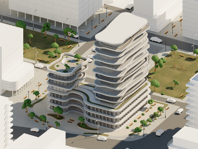
Did you know that one employee on an average salary of $50,000 making two hour-long site visits per day could cost up to $34,000 per year in labour and travel?[1] Thousands of organisations save by replacing some of the site visits with remote site assessments using Nearmap's clear up-to-date aerial imagery. 


Want to know how? Request an obligation-free demo to learn how Nearmap's high-resolution aerial imagery can help you:

  1. Start site planning without physically being there
  2. Enhance on-site productivity and reduce time on site
  3. Make it possible to inspect an area immediately
  4. Easily monitor progress over time

Businesses and government organisations choose Nearmap to help reduce operational costs:

Instant access to high-quality visuals helps companies save both time and money in urban development planning with detailed and precise site information, delivered straight to their desktop. This empowers everyone involved in urban planning to map, measure, monitor and share the progress of a project with all stakeholders.

The benefit is having visibility of projects from acquisition or tender, through to finished asset via cloud-based high-resolution aerial images. Some of the organisations that use up-to-date aerial images to manage their projects are Cardno, Brisbane City Council and Brookfield Rail.

Typically, urban planners and project managers are frustrated by a lack of current project imagery, concerned about the cost involved in continued site visits or annoyed at the delays in relaying critical project information. Are any of these concerns for you? If you would like to find out more, get in touch with Nearmap for an obligation-free demo.

[1] http://www.nearmap.com.au/savings-calculator 


Reduce Site Visits with Aerial Imagery
Universal Magazines
Website
Send Enquiry To Nearmap
SEARCH


MORE NEWS

REVOLUTIONISING LANDSCAPE DESIGN CUTTING-EDGE SOFTWARE
DON’T COMPROMISE! GET A LAPTOP MADE FOR LANDSCAPERS
EMBRACING THE FUTURE: HOW AI IS REVOLUTIONISING LANDSCAPE DESIGN
GREAT DESIGN DESERVES GREAT POWER
5 REASONS WHY YOU SHOULD INVEST IN REAL-TIME RENDERING FOR LANDSCAPE DESIGN & ARCHITECTURE
REVOLUTIONISE LANDSCAPE DESIGN WITH LANDWORKSCAD: GATEWAY TO EffORTLESS EXCELLENCE


PROMOTE YOUR BUSINESS
MEDIA KIT
ORDER ODS
SITEMAP
ABOUT US
PRIVACY POLICY
TERMS & CONDITIONS
CONTACT US.
INDUSTRY ASSOCIATIONS
SUBSCRIBE TO OUR ENEWS
do not click


Send Enquiry